
Sections
Services
Highlight

Óscar Bartual Bardisa
Alicante
Lunes, 31 de marzo 2025, 10:10
March has been a month of heavy rainfall. In a hydrological year marked by drought, the successive storms that have entered the peninsula this month, up to four, have brought significant precipitation to the region, filling reservoirs and accumulating in several municipalities more than 80% of the annual rainfall in just one month.
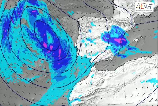
After a few days of sunshine and completely clear skies thanks to the anticyclones that have kept the storms at bay, the rains are returning. They will start from Wednesday, as forecasted by the State Meteorological Agency (Aemet).
🌂➡️☔️ The week begins with little rain, but new Atlantic storms will bring rainy weather, especially from Wednesday. The precipitation will be geographically widespread.
AEMET (@AEMET_Esp) March 30, 2025
👉 On the night of Monday 31, there may be heavy showers in the Canary Islands. pic.twitter.com/YEsFEHx6u4
After lingering over the peninsula, the anticyclone has moved north to Europe, giving way to the storms. In fact, one will arrive from the Atlantic Ocean in the coming days, bringing the first showers on Tuesday to the western edge of the peninsula, and then pouring down again in the province from Tuesday.
The Aemet warns that the week will start "with little rain, but new Atlantic storms will bring rainy weather, especially from Wednesday," and assures that the showers "will be geographically widespread."
¡#HappySunday! The #Anticyclone, after spending a few days in its comfort zone, is going to move back to the vicinity of the British Isles and Scandinavia. The #Storms will once again have free rein to reach the #IberianPeninsula. It will be from Wednesday (02/04/2025). pic.twitter.com/spURmuJz3W
MeteOrihuela (@MeteOrihuela) March 30, 2025
According to Aemet forecasts, it will rain across the province from Wednesday, with a probability of over 95%, although the heaviest showers are expected in the northern coast and in the interior and mountains of Alicante, where they may even be accompanied by storms. These rains are expected to continue at least until Friday.
Regarding temperatures, a slight drop is expected in the coming days, especially in the maximums, which in several coastal municipalities will fall below 20 degrees, while the minimums slightly rise on the coast, but not in the interior, where they will be below 10 degrees at the start of April.
Looking ahead to Easter, forecasts remain uncertain and instability prevails. It is still too early to know if there will be rain, and the weather that prevailed in March is affecting bookings, which are waiting for last-minute updates to know the forecasts.
Publicidad
Publicidad
Te puede interesar
Publicidad
Publicidad
Esta funcionalidad es exclusiva para registrados.
Reporta un error en esta noticia

Debido a un error no hemos podido dar de alta tu suscripción.
Por favor, ponte en contacto con Atención al Cliente.

¡Bienvenido a TODOALICANTE!

Tu suscripción con Google se ha realizado correctamente, pero ya tenías otra suscripción activa en TODOALICANTE.
Déjanos tus datos y nos pondremos en contacto contigo para analizar tu caso

¡Tu suscripción con Google se ha realizado correctamente!
La compra se ha asociado al siguiente email
Comentar es una ventaja exclusiva para registrados
¿Ya eres registrado?
Inicia sesiónNecesitas ser suscriptor para poder votar.